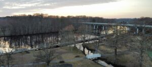
Pocomoke City residents now have access to localized tide and water level data, thanks to a new partnership focused on improving awareness of changing river conditions. The tide gauge, manufactured by Sentient Things, was recently installed along the Pocomoke River through a collaboration with the Arrowhead. Installation and site selection were carried out with assistance from GEY Engineers and Surveyors, who helped identify a suitable location and assisted with installation of the equipment. The effort was driven by a clear gap in available data, until now, there had been no tide monitoring station providing readings specific to the Pocomoke area.
Accurate, real-time water level data can play an important role in a waterfront community like Pocomoke City. Previously, residents and officials often had to rely on data from distant monitoring stations that did not always reflect local river conditions. This new gauge provides a clearer, more precise picture of water levels along the Pocomoke River.
Beyond everyday awareness, the tide gauge is expected to be a valuable tool during high water events. Real-time data, including visibility into rising water levels and upcoming high tides, can help emergency responders and local officials better understand conditions as they develop.
To support the project, Sentient Things provided the tide gauge to the Arrowhead at no cost to serve the community.
Powered by Tide Alerts
Data from the gauge is made available through Tide Alerts, a platform operated by Sentient Things that provides several tools for monitoring and planning around water levels:
- Live Monitoring – Real-time updates from solar-powered gauges connected via a cellular network
- Interactive Maps – View station locations with current water levels and access detailed charts
- Tide Charts & Tables – Explore historical trends and future tide predictions
- Calendar Integration – Sync tide events with Google Calendar, Apple Calendar, Outlook, and other apps
- Threshold Tracking – Identify when water levels may impact navigation or waterfront access
- Custom Alerts (Coming Soon) – Notifications when water levels reach user-defined thresholds
These features allow residents, boaters, and officials to better understand and plan around changing water conditions. While the data is accessible for free, users can subscribe to Tide Alerts through their website for additional features.
A Community-Focused Effort
The project reflects a shared commitment to providing useful, accessible information to the public. With the gauge now in place, Pocomoke City gains a long-needed source of localized water data. As more information is collected over time, it may also contribute to better planning, preparedness, and understanding of how the river behaves during both routine and severe conditions.
To access the data, find the link “Click for River Tide Data” on the Arrowhead website. As the sensor was just brought online at the time of this article, it will take a few days for prediction data to populate.